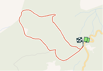
![](/images/other/stat-length.png)
![Excursión Bici de montaña La Tour-d'Auvergne - Espace VTT FFC du Sancy - Circuit n°42 - Le Plateau - Secteur Base Nordique de la Stèle - Photo](https://media.geolcdn.com/t/1900/400/ext.pjpeg?maxdim=2&url=https%3A%2F%2Fservices.sitytrail.com%2FGeolivesWS%2FDownloadMedia.ashx%3FTrailID%3D172902%26Media%3D14362_1.jpg)
Espace VTT FFC du Sancy - Circuit n°42 - Le Plateau - Secteur Base Nordique de la Stèle
tracegps
Usuario
![Longitud](/images/other/stat-length.png)
![Altitud máxima](https://static1.geolcdn.com/siteimages/upload/files/1508320355ic_sort_altitude_max_24dp.png)
![Desnivel positivo](https://static1.geolcdn.com/siteimages/upload/files/1508320355ic_sort_den_pos_24dp.png)
![Km-Effort](/images/other/stat-length.png)
![Altitud mínima](https://static1.geolcdn.com/siteimages/upload/files/1508320355ic_sort_altitude_min_24dp.png)
![Desnivel negativo](https://static1.geolcdn.com/siteimages/upload/files/1508320355ic_sort_den_neg_24dp.png)
![Boucle](https://static1.geolcdn.com/siteimages/upload/files/16400158638029165_repeat_loop_refresh_sync_direction_icon.png)
![Bici de montaña](https://static1.geolcdn.com/sitytour/trail-icons/202.png)
15m
Dificultad : Medio
![Escanee este código QR para abrir la excursión en la aplicación SityTrail](https://capi.geolives.com/qq0zvz2zws4bq2lad0pu/sitytour/trails/172902/qr.png?size=200)
Aplicación GPS de excursión GRATIS
A propósito
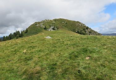
Ruta Bici de montaña de 4,5 km a descubrir en Auvergne-Rhône-Alpes, Puy-de-Dôme, La Tour-d'Auvergne. Esta ruta ha sido propuesta por tracegps.
Descripción
Circuit officiel labellisé par la Fédération Française de Cyclisme. Secteur familial en grande partie en sous bois avec un faible dénivelé. Départ du parking du secteur nordique "La Stèle", route de la Tour d'Auvergne. . Téléchargez le plan des circuits.
Localización
Comentarios
Excursiones cerca
![Excursión Senderismo La Tour-d'Auvergne - Tour_Auvergne_Chambourguet - Photo](https://media.geolcdn.com/t/375/260/89f1026c-dcfd-4eec-ac48-a164d692d4ad.jpg&format=jpg&maxdim=2)
![Senderismo Senderismo](https://static1.geolcdn.com/sitytour/trail-icons/101.png)
Senderismo
![](/images/other/stat-length.png)
![](https://static1.geolcdn.com/siteimages/upload/files/16400158638029165_repeat_loop_refresh_sync_direction_icon.png)
![Excursión Senderismo La Bourboule - Bourboule_Vendeix_Charlannes - Photo](https://media.geolcdn.com/t/375/260/974b84fb-245b-4e5c-88f2-976a8059b2eb.jpg&format=jpg&maxdim=2)
![Senderismo Senderismo](https://static1.geolcdn.com/sitytour/trail-icons/101.png)
Senderismo
![](/images/other/stat-length.png)
![](https://static1.geolcdn.com/siteimages/upload/files/16400158638029165_repeat_loop_refresh_sync_direction_icon.png)
![Excursión Senderismo Chastreix - Chastreix. cascades et tourbières - Photo](https://media.geolcdn.com/t/375/260/ext.jpg?maxdim=2&url=https%3A%2F%2Fservices.sitytrail.com%2FGeolivesWS%2FDownloadMedia.ashx%3FTrailID%3D449099%26Media%3Dfix__20150723174649.jpg)
![Senderismo Senderismo](https://static1.geolcdn.com/sitytour/trail-icons/101.png)
Senderismo
![](/images/other/stat-length.png)
![](https://static1.geolcdn.com/siteimages/upload/files/16400158638029165_repeat_loop_refresh_sync_direction_icon.png)
![Excursión Senderismo Mont-Dore - Le puy de la tache, le lacs servières et guèry par la cascade du Queureuilh depuis l'Escalidou. - Photo](https://media.geolcdn.com/t/375/260/ext.jpg?maxdim=2&url=https%3A%2F%2Fservices.sitytrail.com%2FGeolivesWS%2FDownloadMedia.ashx%3FTrailID%3D228422%26Media%3D20131022164253.jpg)
![Senderismo Senderismo](https://static1.geolcdn.com/sitytour/trail-icons/101.png)
Senderismo
![](/images/other/stat-length.png)
![](https://static1.geolcdn.com/siteimages/upload/files/16400158638029165_repeat_loop_refresh_sync_direction_icon.png)
![Excursión A pie La Tour-d'Auvergne - Chambourguet - Photo](https://media.geolcdn.com/t/375/260/cae5925b-61ac-47d4-b021-c5bfebecd2dc.jpeg&format=jpg&maxdim=2)
![A pie A pie](https://static1.geolcdn.com/sitytour/trail-icons/100.png)
A pie
![](/images/other/stat-length.png)
![](https://static1.geolcdn.com/siteimages/upload/files/16400158638029165_repeat_loop_refresh_sync_direction_icon.png)
![Excursión A pie Chastreix - Bois de la Masse - Photo](https://media.geolcdn.com/t/375/260/e7e44e0f-5c3a-45fa-ad81-e2da1af49124.jpeg&format=jpg&maxdim=2)
![A pie A pie](https://static1.geolcdn.com/sitytour/trail-icons/100.png)
A pie
![](/images/other/stat-length.png)
![](https://static1.geolcdn.com/siteimages/upload/files/16400158638029165_repeat_loop_refresh_sync_direction_icon.png)
![Excursión A pie La Tour-d'Auvergne - Notre Dame de Natzy - Photo](https://media.geolcdn.com/t/375/260/4106d8eb-9b29-4b2a-88f3-8e2eaf175257.jpeg&format=jpg&maxdim=2)
![A pie A pie](https://static1.geolcdn.com/sitytour/trail-icons/100.png)
A pie
![](/images/other/stat-length.png)
![](https://static1.geolcdn.com/siteimages/upload/files/16400158638029165_repeat_loop_refresh_sync_direction_icon.png)
![Excursión A pie La Bourboule - Charlannes et la roche des fées - Photo](https://media.geolcdn.com/t/375/260/efdde1a2-e2f7-4107-8508-7362482215b9.jpeg&format=jpg&maxdim=2)
![A pie A pie](https://static1.geolcdn.com/sitytour/trail-icons/100.png)
A pie
![](/images/other/stat-length.png)
![](https://static1.geolcdn.com/siteimages/upload/files/16400158638029165_repeat_loop_refresh_sync_direction_icon.png)
![Excursión A pie Mont-Dore - Le Capucin et le Puy de Cliergue - Photo](https://media.geolcdn.com/t/375/260/0a0433ed-5dc0-4bcd-94e6-37a94f9acbcf.jpeg&format=jpg&maxdim=2)
![A pie A pie](https://static1.geolcdn.com/sitytour/trail-icons/100.png)
A pie
![](/images/other/stat-length.png)
![](https://static1.geolcdn.com/siteimages/upload/files/16400158638029165_repeat_loop_refresh_sync_direction_icon.png)